


My Son Sanctuary map: Layout, walking route guide
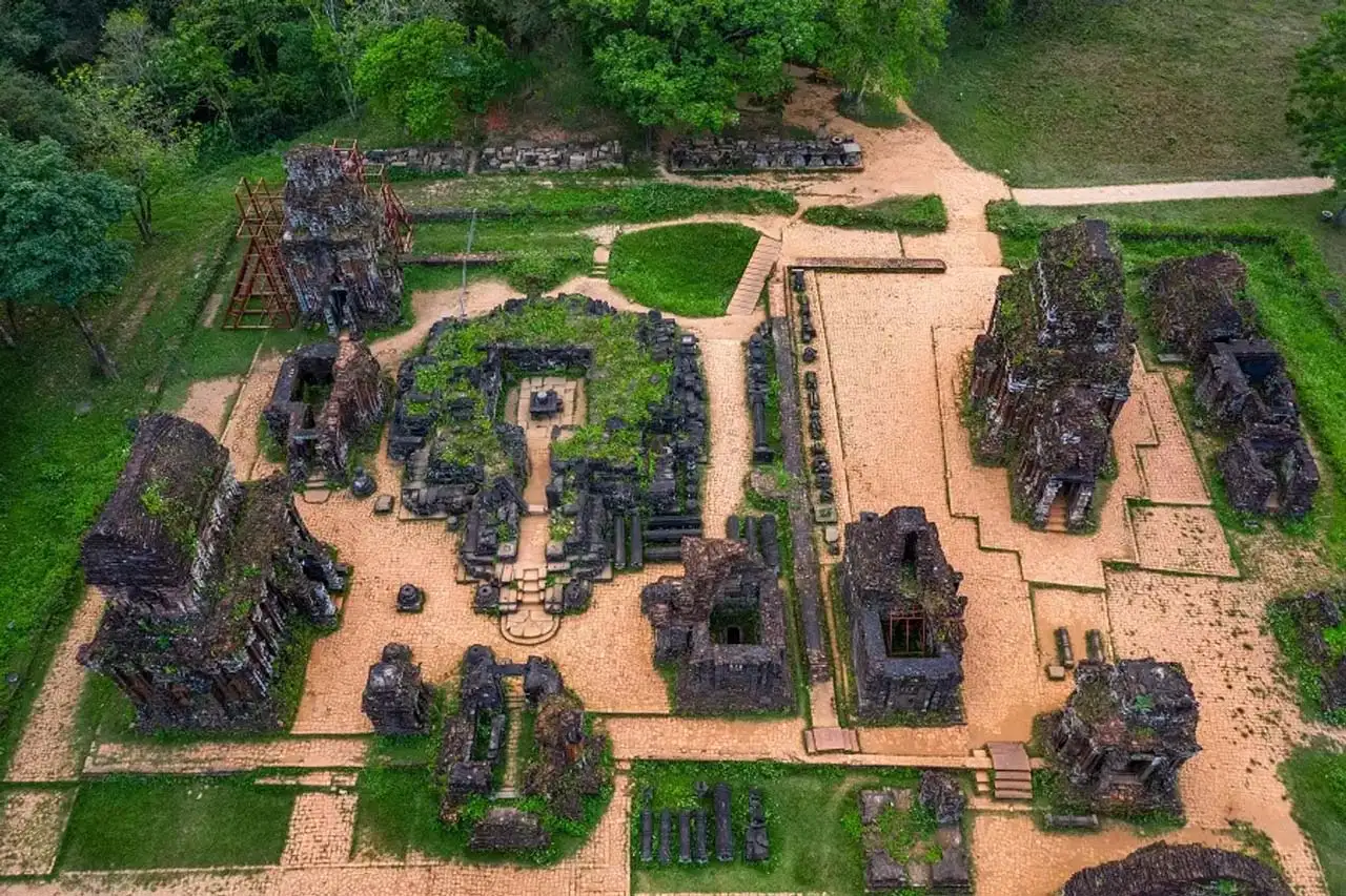
If you are planning a visit to My Son Sanctuary, reviewing the My Son Sanctuary map in advance can make a significant difference in your experience. Unlike compact historical sites, My Son is spread across a wide valley, with temple groups arranged in separate clusters rather than in a single straight line. In this guide, you’ll learn about the temple group layout, the best walking routes, key highlights marked on the map, and practical navigation tips for a smooth and enjoyable visit.
Overview of My Son Sanctuary map
Before visiting My Son Sanctuary, understanding the My Son Sanctuary map can make your trip much easier and more organized. Unlike some historical sites with a single main pathway, My Son is spread out across a wide valley, with different temple groups located in separate clusters.
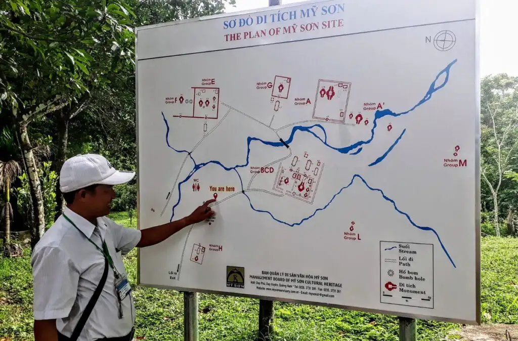
The overall map of My Son Sanctuary Vietnam shows that the site sits in a natural bowl-shaped valley surrounded by low mountains. The temples are not built in one central area but are divided into groups labeled with letters such as A, B, C, D, E, F, G, H, and K. Each group represents a different collection of towers, built during various periods of the Champa Kingdom.
On the My Son Sanctuary map layout, you will see that the main entrance is located outside the protected core area. Visitors typically take an electric shuttle from the entrance to the central zone, and from there, explore the temple groups on foot. The B, C, and D groups are considered the central and most accessible areas, as they contain some of the best-preserved structures.
The map also marks important visitor facilities, including walking paths, the Cham cultural performance area, a small museum or exhibition space, rest areas, and restrooms. This makes the My Son Sanctuary map not just a layout of temple ruins, but a practical guide to planning your visit efficiently.
By understanding the site’s structure in advance, you can avoid confusion, choose a logical walking route, and make the most of your time exploring this UNESCO World Heritage.
Read more: My Son Sanctuary entrance fee 2026 – Ticket price, inclusions & Extra costs
Understanding the layout of My Son Sanctuary
To use the My Son Sanctuary map effectively, it’s important to understand how the site is organized. My Son Sanctuary was not designed around a single straight axis or central courtyard like many other temple complexes. Instead, it developed over centuries as separate architectural clusters spread throughout a natural valley.
The natural valley structure
The entire sanctuary sits within a valley surrounded by low mountains, creating a relatively enclosed setting. On the My Son Sanctuary map layout, you will notice that the temple groups are distributed along walking paths, nestled among trees and natural terrain. Because of this landscape, distances between groups can feel longer than expected, which makes reviewing the map beforehand especially helpful.
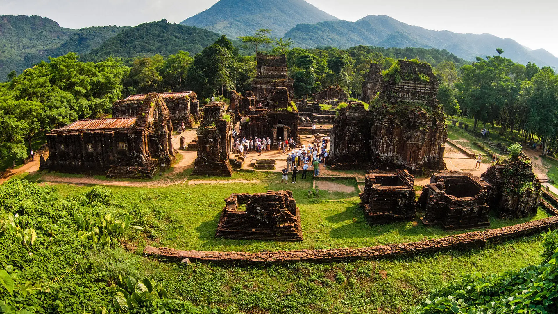
Most visits begin at the central arrival area, where electric shuttles drop visitors off after entering through the main gate. From there, you explore the temple groups on foot, typically following a semi-circular route through the valley. This layout allows for a logical walking flow without too much backtracking if you plan your route well.
Main temple groups on the map
On the My Son Sanctuary map, the temple clusters are labeled with letters such as A, B, C, D, E, F, G, H, and K. These labels were assigned by archaeologists to classify and study the structures more easily.
The B, C, and D groups are generally considered the central and most accessible areas, as they contain several relatively well-preserved towers. Group A was once one of the most significant areas but suffered heavy damage during wartime. Group G and some other clusters have undergone restoration efforts in recent years and are now important highlights of the site.
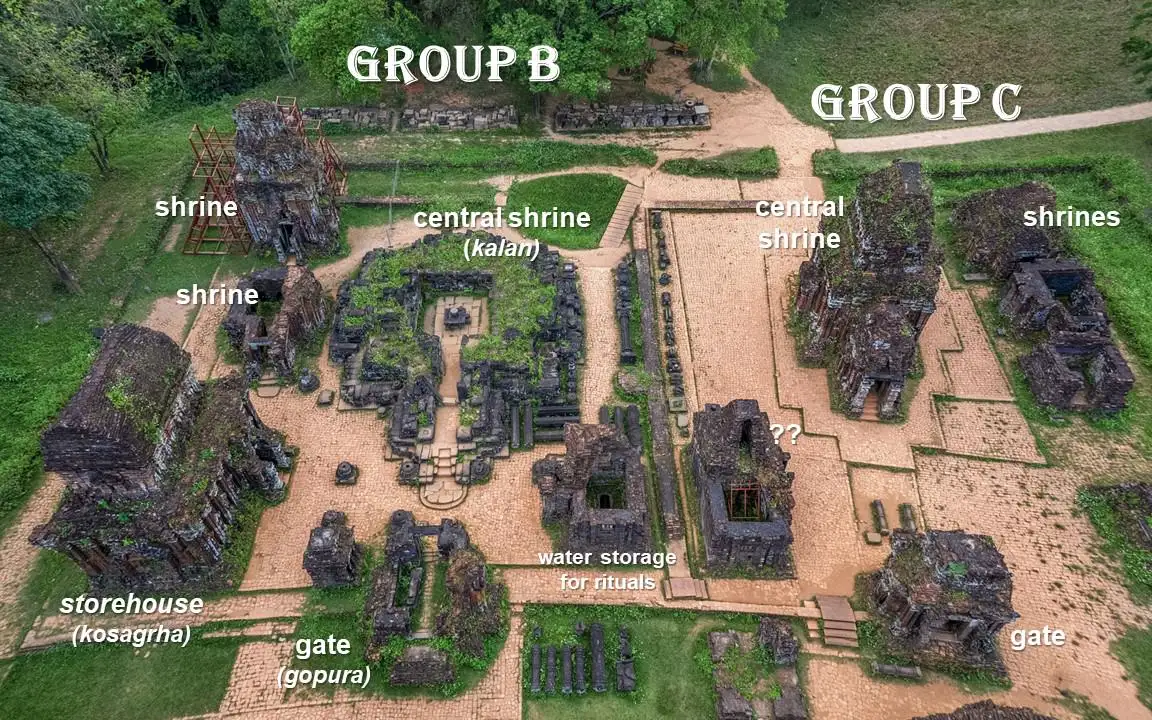
Each group typically includes a main tower (kalan), gate towers, and smaller supporting structures. When looking at the map of My Son Sanctuary Vietnam, you’ll see that these groups are not tightly packed together. Instead, they are separated by greenery and open space, giving visitors a sense of gradual discovery as they move from one cluster to another.
After reviewing the My Son Sanctuary map and planning your walking route, you may prefer a guided experience that helps you understand the layout, temple groups, and historical context more deeply. If so, Bliss Hoi An Beach Resort & Wellness offers carefully designed tours that align perfectly with the route and highlights discussed in this guide.
If you prefer a hassle-free experience, the My Son Sanctuary Tour by Bliss Hoi An Beach Resort & Wellness lets you explore the key temple groups with expert guidance, no need to navigate the My Son Sanctuary map on your own. For a full cultural day trip, the My Son Sanctuary & Marble Mountains Tour combines the ancient Cham temples with a visit to Marble Mountains, giving you two iconic heritage sites in one seamless itinerary.
Key highlights marked on the map
When reviewing the My Son Sanctuary map, you’ll notice that it highlights not only the main temple groups but also important visitor areas such as performance spaces, exhibition zones, and walking paths. Understanding what makes each area special will help you explore more intentionally and naturally discover the best photo opportunities at My Son Sanctuary.
Groups B, C, and D – The Central Core
On the My Son Sanctuary map layout, Groups B, C, and D form the central core of the complex. This is the most important and most visited area, where several structures remain relatively well preserved. The towers are located close to one another, making it easier to observe the overall Cham architectural layout, including the main sanctuary tower (kalan) and surrounding auxiliary structures.
This area is especially beautiful in the early morning, when sunlight falls at an angle across the red brick surfaces, creating strong light and shadow contrasts. Standing in the open space between Groups C and D, with the ancient towers behind you and the surrounding hills in the distance, allows you to capture a balanced image that highlights both the architecture and the natural setting.
Group G – A Notable Restored Area
According to the map of My Son Sanctuary Vietnam, Group G is located slightly farther from the central zone. This cluster has undergone significant restoration in recent years, and several towers here retain a clearer structural form.
Because it is less crowded than Groups B, C, and D, Group G offers a quieter atmosphere for exploring architectural details. When taking photos, positioning yourself at a slightly lower angle and framing the main tower against the sky can emphasize its height and structure. Late morning light often enhances the deep red tones of the brick against a bright blue sky.
Cham Cultural Performance Area
The My Son Sanctuary map also marks the traditional Cham performance area near the central zone. Visitors can watch short dance and music performances that reflect Cham cultural heritage.
If you attend a performance, capturing a dancer in traditional costume with ancient towers in the background creates a visually rich image that combines movement, culture, and history in a single frame.
Read more: My Son Sanctuary dress code: What to wear & Essential clothing tips
Downloading and accessing the official My Son Sanctuary map
Before visiting My Son Sanctuary, many travelers prefer to check the My Son Sanctuary map in advance to plan their route. Having access to the official map, either before arrival or at the site, can help you save time and avoid confusion once you begin exploring.
Getting the map on site
The easiest and most reliable way to access the My Son Sanctuary map is to obtain a printed copy at the ticket counter or visitor information center. In most cases, a paper map is provided free of charge with your entrance ticket. You will also find a large display board near the main visitor area showing the full My Son Sanctuary map layout, allowing you to study the overall structure before starting your walk.
The official printed map clearly marks:
- Temple groups labeled A, B, C, D, G, E, and others
- Main walking paths
- The Cham cultural performance area
- Restrooms and rest areas
This on-site version is typically the most accurate and up-to-date reference available to visitors.
Finding the map online before your trip
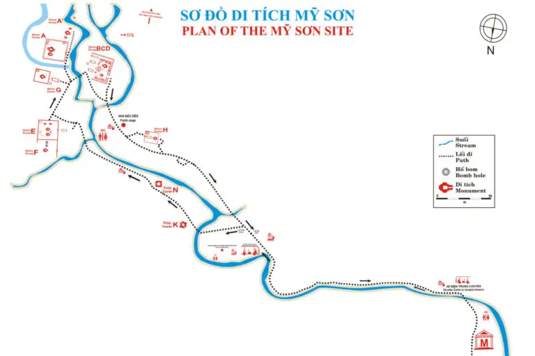
If you prefer to prepare ahead of time, you can search for a map of My Son Sanctuary Vietnam on travel websites, blogs, or tourism platforms. Some sources provide downloadable image files or PDF versions of the My Son Sanctuary map that you can save offline for convenience.
However, keep in mind that not all online versions are official or recently updated. Layout adjustments or restoration work may not always be reflected in older maps. For this reason, it is still advisable to compare any digital version with the official map provided at the site.
Walking route based on the map
When you look at the My Son Sanctuary map, you will see many temple groups labeled with letters such as B, C, D, G, and E. If you only look at the letters, it can be hard to remember what each area actually offers. Below is a simple and easy-to-follow walking plan suggested by Bliss Hoi An Beach Resort & Wellness to help you explore My Son Sanctuary without feeling overwhelmed.
1–2 hour route: Focus on the Main Highlights
If you have limited time, concentrate on Groups B, C, and D. These are located in the central area of the My Son Sanctuary map layout and contain some of the most important and accessible structures.

Group B is often the first area visitors reach. Here, you can see the remains of main temple towers along with surrounding structures. Although some parts are damaged, the overall layout helps you understand how Cham temples were originally designed.
Group C is considered one of the most impressive clusters. Several towers are relatively well preserved, making it easier to observe architectural details. This area is also popular for photography because the towers stand close together and create a striking visual scene.
Group D is located near Group C and includes partially restored structures. This helps visitors better imagine how the complex once looked in its complete form.
On the map of My Son Sanctuary Vietnam, these three groups are positioned close to each other, forming a small loop. By walking in one direction, such as clockwise, you can explore all three areas without retracing your steps.
3–4 Hour Route: Explore Beyond the Center
If you have more time and want a deeper experience, continue from Groups B, C, and D to Group G and Group E, as shown on the My Son Sanctuary map.
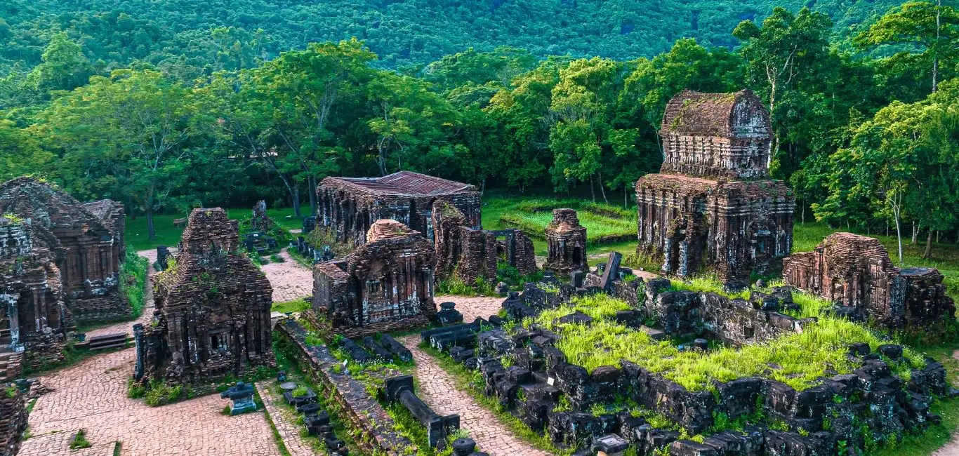
Group G is one of the areas that has undergone notable restoration in recent years. Some towers here remain in relatively good condition, allowing you to better understand the original scale of the sanctuary. This area is usually quieter than the central groups.
Group E is located a bit farther away. While many structures here are more heavily damaged, visiting this cluster helps you realize how large and significant the My Son complex once was.
When exploring the extended areas, it is best to continue following a large circular path rather than returning to the central zone after each group. On the My Son Sanctuary map layout, the temple clusters are arranged in a natural arc shape, so walking in a loop will save energy and reduce unnecessary backtracking.
Tips for navigating My Son Sanctuary efficiently
Exploring My Son Sanctuary can be much more enjoyable if you plan your movement carefully. Since the site is spread across a wide valley and the temple groups are located in separate clusters, a few simple strategies can help you save time and energy while making the most of the My Son Sanctuary map.
Walk in a clockwise direction
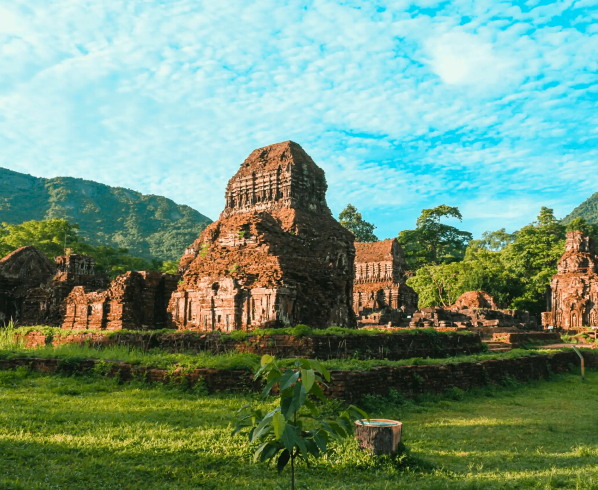
When following the My Son Sanctuary map layout, it is generally more efficient to choose one consistent direction, such as walking clockwise, rather than moving randomly between temple groups. Because the clusters are arranged in a natural arc, walking in a loop reduces backtracking and prevents unnecessary walking in the heat. This approach allows you to cover the central groups smoothly before expanding outward.
Avoid the midday heat
The valley offers limited shade, and temperatures can become very high around midday. To navigate comfortably, try to arrive early in the morning or later in the afternoon. Exploring during cooler hours not only makes walking easier but also enhances your overall experience, especially if you plan to visit multiple temple groups shown on the My Son Sanctuary map.
Bring water and stay hydrated
The sanctuary covers a large outdoor area, and walking between temple clusters can take more time than expected. Carrying a bottle of water is essential, particularly during the dry season. Although there are rest areas marked on the map, having water with you ensures you can move at your own pace without discomfort.
Visit groups B, C, and D early for photography
If photography is a priority, plan to explore Groups B, C, and D early in the morning. These central clusters, clearly marked on the map of My Son Sanctuary Vietnam, receive soft angled sunlight that highlights the red brick textures and architectural details. Visiting early also means fewer crowds, allowing you to capture cleaner and more atmospheric images.
By following these practical tips and using the My Son Sanctuary map strategically, you can navigate the complex more efficiently and enjoy a smoother, more rewarding visit.
FAQs about My Son Sanctuary map
Below are some frequently asked questions about the My Son Sanctuary map to help you prepare for your visit to My Son Sanctuary more confidently and efficiently.
Is My Son Sanctuary easy to navigate?
Yes, the site is generally easy to explore, but it can feel slightly confusing at first because the temple groups are spread out across a valley. By using the My Son Sanctuary map, you will see that the clusters are arranged in a natural arc. If you follow one consistent direction, such as walking clockwise, you can move smoothly between groups without getting lost or retracing your steps unnecessarily.
How big is My Son Sanctuary?
The sanctuary covers a fairly large valley area with multiple temple clusters located at different distances from one another. While it is not overwhelmingly massive, you should allow at least 2 to 4 hours for a complete visit. Looking at the map of My Son Sanctuary Vietnam, you’ll notice that Groups B, C, and D are centrally located and close together, while groups such as G and E are positioned farther away and require more walking.
Do I need a guide to understand the map?
Hiring a guide is not mandatory. The My Son Sanctuary map layout is clear enough for independent visitors to navigate the site on their own. However, if you are interested in learning more about the historical background, architectural symbolism, and religious significance of each temple group, a guide can greatly enhance your understanding beyond what the map alone provides.
Is there a digital map available?
There is currently no official standalone digital app for the internal layout. You may find image versions or PDF files of the My Son Sanctuary map on travel websites or blogs. While Google Maps helps you locate the sanctuary geographically, it does not display detailed internal temple group layouts like the official on-site map does. For exploring inside the complex, the printed map provided at the entrance remains the most practical reference.
Which temple groups should I prioritize if I have limited time?
If your time is limited, focus on Groups B, C, and D. These central clusters, clearly marked on the My Son Sanctuary map, contain some of the most preserved and visually impressive structures. Visiting these groups gives you a strong overall impression of the sanctuary’s architectural style and historical significance.
Can I explore without following the map?
Yes, you can follow the marked walking paths without actively studying the map. However, skipping the My Son Sanctuary map may cause you to miss certain temple groups or walk unnecessary extra distances. Reviewing the map beforehand helps you create a logical route, manage your time effectively, and ensure a smoother visit.
By reviewing My Son Sanctuary map, identifying the main temple groups, and planning your walking route in advance, you can explore the site more efficiently and with greater appreciation. With a clear understanding of the layout, your visit becomes more structured, less tiring, and ultimately more rewarding, allowing you to focus on the beauty, history, and atmosphere of this remarkable UNESCO World Heritage Site.

Related Posts

Private Tours from Hoi An Beach Resorts: Discover Central Vietnam from Bliss Hoi An

How much does a Hoi An wedding for 40 guests cost?

Is fine dining Hoi An really worth the price? What are travelers paying for?
Cau Bong Festival in Hoi An: Inside Tra Que’s Agricultural New Year Tradition

Top 8 things to consider for a wedding in Hoi An with 20 guests